Geolocate

Przymorze Małe topographic map

Interactive map

Click on the map to display elevation.

About this map

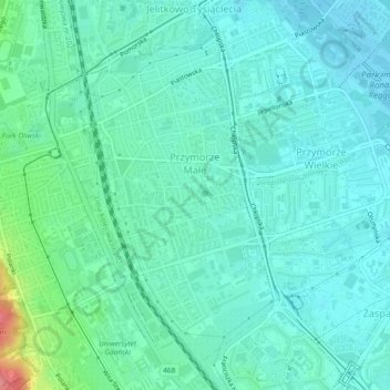
Name: Przymorze Małe topographic map, elevation, terrain.

Location: Przymorze Małe, Gdansk, Gdańsk, Pomeranian Voivodeship, Poland (54.39533 18.57031 54.41858 18.59266)

Average elevation: 17 m

Minimum elevation: 0 m

Maximum elevation: 84 m

Other topographic maps

Click on a map to view its topography, its elevation and its terrain.

Gdansk

Poland > Pomeranian Voivodeship > Gdansk

Gdansk, Pomeranian Voivodeship, Poland

Average elevation: 59 m

Gdansk

Poland > Pomeranian Voivodeship > Gdansk

Gdansk, Pomeranian Voivodeship, Poland

Average elevation: 46 m

Aniołki

Poland > Pomeranian Voivodeship > Gdansk

Aniołki, Gdansk, Gdańsk, Pomeranian Voivodeship, Poland

Average elevation: 27 m

Zaspa-Młyniec

Poland > Pomeranian Voivodeship > Gdansk

Zaspa-Młyniec, Gdansk, Gdańsk, Pomeranian Voivodeship, Poland

Average elevation: 17 m