
Make a donation
Gear up for your next adventure:
As an Amazon Associate, this site earns from qualifying purchases at no extra cost to you.
Cranwich topographic map
Click on the map to display elevation.
Make a donation
Gear up for your next adventure:
As an Amazon Associate, this site earns from qualifying purchases at no extra cost to you.
About this map
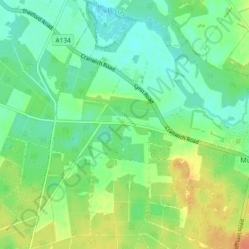
Name: Cranwich topographic map, elevation, terrain.
Location: Cranwich, Breckland District, Norfolk, England, United Kingdom (52.49515 0.59687 52.53478 0.64036)
Average elevation: 18 m
Minimum elevation: 4 m
Maximum elevation: 41 m
Norfolk trails, hiking, mountain biking, running and outdoor activities
Make a donation
Gear up for your next adventure:
As an Amazon Associate, this site earns from qualifying purchases at no extra cost to you.
Other topographic maps
Click on a map to view its topography, its elevation and its terrain.
Make a donation
Gear up for your next adventure:
As an Amazon Associate, this site earns from qualifying purchases at no extra cost to you.
Make a donation
Gear up for your next adventure:
As an Amazon Associate, this site earns from qualifying purchases at no extra cost to you.
Make a donation
Gear up for your next adventure:
As an Amazon Associate, this site earns from qualifying purchases at no extra cost to you.
Saham Hills
United Kingdom > England > Norfolk > Breckland District > Saham Toney
Average elevation: 61 m
Make a donation
Gear up for your next adventure:
As an Amazon Associate, this site earns from qualifying purchases at no extra cost to you.
Haverscroft Street
United Kingdom > England > Norfolk > Breckland District > Attleborough
Average elevation: 34 m
Make a donation
Gear up for your next adventure:
As an Amazon Associate, this site earns from qualifying purchases at no extra cost to you.
Stonebridge
United Kingdom > England > Norfolk > Breckland District > East Wretham
Average elevation: 38 m
Southburgh
United Kingdom > England > Norfolk > Breckland District > Cranworth > Southburgh
Average elevation: 55 m
Thorpe Row
United Kingdom > England > Norfolk > Breckland District > Thorpe Row
Average elevation: 69 m
Make a donation
Gear up for your next adventure:
As an Amazon Associate, this site earns from qualifying purchases at no extra cost to you.
Dam Green
United Kingdom > England > Norfolk > Breckland District > Kenninghall
Average elevation: 46 m
Make a donation
Gear up for your next adventure:
As an Amazon Associate, this site earns from qualifying purchases at no extra cost to you.