
Senapathy topographic map
Interactive map
Click on the map to display elevation.
About this map
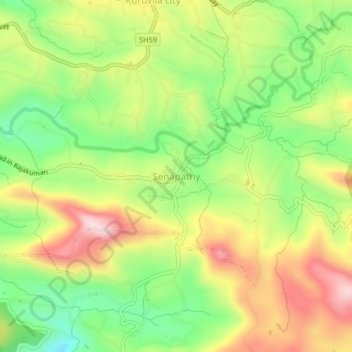
Name: Senapathy topographic map, elevation, terrain.
Location: Senapathy, Udumbanchola, Idukki District, Kerala, 685619, India (9.93074 77.16157 9.97074 77.20157)
Average elevation: 1,051 m
Minimum elevation: 894 m
Maximum elevation: 1,234 m
Other topographic maps
Click on a map to view its topography, its elevation and its terrain.
Chempakapara
India > Kerala > Udumbanchola > Chempakappara > Kochukamakshy
Chempakapara, Kochukamakshy, Chempakappara, Udumbanchola, Idukki District, Kerala, India
Average elevation: 811 m
Panniyarkutty
India > Kerala > Udumbanchola > Rajakkaad
Panniyarkutty, Rajakkaad, Udumbanchola, Idukki District, Kerala, 685566, India
Average elevation: 724 m
Choondal
India > Kerala > Udumbanchola
Choondal, Udumbanchola, Idukki District, Kerala, India
Average elevation: 1,414 m
Anakkara
India > Kerala > Udumbanchola
Anakkara, Udumbanchola, Idukki District, Kerala, India
Average elevation: 1,050 m