
Make a donation
Gear up for your next adventure:
As an Amazon Associate, this site earns from qualifying purchases at no extra cost to you.
El Portús topographic map
Click on the map to display elevation.
Make a donation
Gear up for your next adventure:
As an Amazon Associate, this site earns from qualifying purchases at no extra cost to you.
About this map
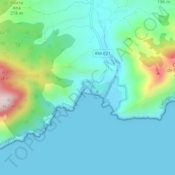
Name: El Portús topographic map, elevation, terrain.
Average elevation: 91 m
Minimum elevation: 0 m
Maximum elevation: 453 m
Make a donation
Gear up for your next adventure:
As an Amazon Associate, this site earns from qualifying purchases at no extra cost to you.
Other topographic maps
Click on a map to view its topography, its elevation and its terrain.
Cabo de Palos
España > Región de Murcia > Campo de Cartagena y Mar Menor > Cartagena
Average elevation: 1 m
La Alberca
España > Región de Murcia > Campo de Cartagena y Mar Menor > Cartagena
Average elevation: 54 m
Fatares
España > Región de Murcia > Campo de Cartagena y Mar Menor > Cartagena
Average elevation: 95 m
Calblanque
España > Región de Murcia > Campo de Cartagena y Mar Menor > Cartagena
Average elevation: 34 m
Make a donation
Gear up for your next adventure:
As an Amazon Associate, this site earns from qualifying purchases at no extra cost to you.
Isla del Ciervo
España > Región de Murcia > Campo de Cartagena y Mar Menor > Cartagena
Average elevation: 1 m
Isla Redonda
España > Región de Murcia > Campo de Cartagena y Mar Menor > Cartagena
Average elevation: 0 m
Isla del Sujeto
España > Región de Murcia > Campo de Cartagena y Mar Menor > Cartagena
Average elevation: 1 m
Peñarroya
España > Región de Murcia > Campo de Cartagena y Mar Menor > Cartagena
Average elevation: 50 m
Make a donation
Gear up for your next adventure:
As an Amazon Associate, this site earns from qualifying purchases at no extra cost to you.
Albujón
España > Región de Murcia > Campo de Cartagena y Mar Menor > Cartagena
Average elevation: 73 m
La Aljorra
España > Región de Murcia > Campo de Cartagena y Mar Menor > Cartagena > La Aljorra
Average elevation: 84 m
Playa de los Alemanes
España > Región de Murcia > Campo de Cartagena y Mar Menor > Cartagena
Average elevation: 2 m
Peña del Águila
España > Región de Murcia > Campo de Cartagena y Mar Menor > Cartagena
Average elevation: 183 m
Make a donation
Gear up for your next adventure:
As an Amazon Associate, this site earns from qualifying purchases at no extra cost to you.
Cueva del Agua
España > Región de Murcia > Campo de Cartagena y Mar Menor > Cartagena
Average elevation: 27 m
Cabo de Palos
España > Región de Murcia > Campo de Cartagena y Mar Menor > Cartagena
Average elevation: 1 m