Geolocate

Brindle topographic map

Click on the map to display elevation.

About this map

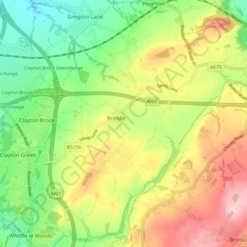
Name: Brindle topographic map, elevation, terrain.

Location: Brindle, Chorley, Lancashire, England, United Kingdom (53.68701 -2.63231 53.73743 -2.57583)

Average elevation: 114 m

Minimum elevation: 28 m

Maximum elevation: 222 m

Lancashire trails, hiking, mountain biking, running and outdoor activities

Gear up for your next adventure:

🧵Survival Paracord - Multi-purpose cordage for emergency repairs and shelters
📚UK Hiking Guidebooks - Detailed route descriptions for the Lake District, Peaks, and Highlands
👟Waterproof Leg Gaiters - Keep mud and water out of your boots in boggy terrain
👟Women's Trail Running Shoes - Agile footwear for fell running and technical trails
🚲Cycling GPS Computers - Track elevation and topographic routes on two wheels

As an Amazon Associate, this site earns from qualifying purchases at no extra cost to you.