
Make a donation
Gear up for your next adventure:
As an Amazon Associate, this site earns from qualifying purchases at no extra cost to you.
Escuintla topographic map
Click on the map to display elevation.
Make a donation
Gear up for your next adventure:
As an Amazon Associate, this site earns from qualifying purchases at no extra cost to you.
Escuintla
e ubica en la Región Socioeconómica X SOCONUSCO. Limita al norte con Siltepec y Capitán Luis A. Vidal, al este con Motozintla, al sur con Huixtla, Villa Comaltitlán y Acapatehua; y al oeste con Acacoyagua. Las coordenadas de la cabecera municipal son: 15°19'10" de latitud norte y 92°39'30" de longitud oeste y se ubica a una altitud de 81 metros sobre el nivel del mar. Con una superficie territorial de 416,58 km² ocupa el 0,56% del territorio estatal.
Make a donation
Gear up for your next adventure:
As an Amazon Associate, this site earns from qualifying purchases at no extra cost to you.
About this map
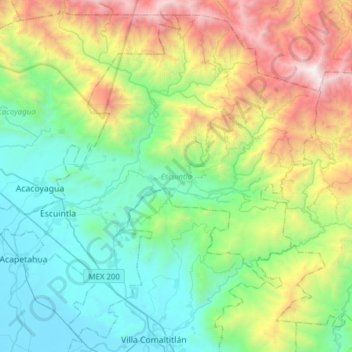
Name: Escuintla topographic map, elevation, terrain.
Location: Escuintla, Chiapas, 30600, México (15.21478 -92.73714 15.48733 -92.42912)
Average elevation: 863 m
Minimum elevation: 8 m
Maximum elevation: 2,918 m
Make a donation
Gear up for your next adventure:
As an Amazon Associate, this site earns from qualifying purchases at no extra cost to you.
Other topographic maps
Click on a map to view its topography, its elevation and its terrain.
Make a donation
Gear up for your next adventure:
As an Amazon Associate, this site earns from qualifying purchases at no extra cost to you.
Make a donation
Gear up for your next adventure:
As an Amazon Associate, this site earns from qualifying purchases at no extra cost to you.