
Make a donation
Gear up for your next adventure:
As an Amazon Associate, this site earns from qualifying purchases at no extra cost to you.
Vercorin topographic map
Click on the map to display elevation.
Make a donation
Gear up for your next adventure:
As an Amazon Associate, this site earns from qualifying purchases at no extra cost to you.
About this map
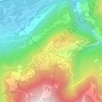
Name: Vercorin topographic map, elevation, terrain.
Location: Vercorin, Chalais, Sierre, Wallis, 3967, Switzerland (46.23717 7.51070 46.27717 7.55070)
Average elevation: 1,120 m
Minimum elevation: 503 m
Maximum elevation: 2,019 m
Make a donation
Gear up for your next adventure:
As an Amazon Associate, this site earns from qualifying purchases at no extra cost to you.
Other topographic maps
Click on a map to view its topography, its elevation and its terrain.
Mollens (VS)
Switzerland > Wallis > Sierre > Crans-Montana
The former municipality is located in the Sierre district, on the right bank of the Rhone river. The municipality stretches from an elevation of 900 to 3,177 m (2,953 to 10,423 ft). It consists of the villages of Mollens and Cordona, the scattered settlements of Conzor, Laques and Saint-Maurice-de-Laques as…
Average elevation: 1,996 m
Crans-Montana
Switzerland > Wallis > Sierre
The resort is located in the heart of the Swiss Alps in the French-speaking part of the canton of Valais. It is located on a plateau above Sierre at an elevation of about 1,500 m (4,920 ft) above sea level, allowing good view over the Valais Alps and Weisshorn in particular. The resort is a fusion of the two…
Average elevation: 1,660 m
Sierre
Switzerland > Wallis > Sierre
The hilly topography of the valley floor derives from a very large postglacial rock avalanche, which collapsed from a fractured scar high to the north.
Average elevation: 1,143 m
Crans-Montana
Switzerland > Wallis > Sierre
The resort is located in the heart of the Swiss Alps in the French-speaking part of the canton of Valais. It is located on a plateau above Sierre at an elevation of about 1,500 m (4,920 ft) above sea level, allowing a panoramic view over the Valais Alps and Weisshorn in particular. The resort is a fusion of…
Average elevation: 1,660 m
Make a donation
Gear up for your next adventure:
As an Amazon Associate, this site earns from qualifying purchases at no extra cost to you.
Randogne
Switzerland > Wallis > Sierre > Crans-Montana
The former municipality is located in the Sierre district, on the northern slope of the Rhone valley. The municipality goes from the Rhone valley at an elevation of 540 m (1,770 ft) to Mont Bonvin at 2,995 m (9,826 ft). It consists of the village of Randogne (which was rebuilt in stone after the destructive…
Average elevation: 1,614 m
Make a donation
Gear up for your next adventure:
As an Amazon Associate, this site earns from qualifying purchases at no extra cost to you.
Randogne
Switzerland > Wallis > Sierre
The former municipality is located in the Sierre district, on the northern slope of the Rhone valley. The municipality goes from the Rhone valley at an elevation of 540 m (1,770 ft) to Mont Bonvin at 2,995 m (9,826 ft). It consists of the village of Randogne (which was rebuilt in stone after the destructive…
Average elevation: 1,614 m
Montana
Switzerland > Wallis > Sierre > Crans-Montana
The former municipality is located in the Sierre district, above the right bank of the Rhone. It consists of the villages of Montana and Corin, part of the Champzabé, the hamlet of Diogne as well as the resort of Montana-Vermala (located at an elevation of 1,500 m (4,900 ft) and shared between Montana and…
Average elevation: 1,231 m
Make a donation
Gear up for your next adventure:
As an Amazon Associate, this site earns from qualifying purchases at no extra cost to you.