
Make a donation
Gear up for your next adventure:
As an Amazon Associate, this site earns from qualifying purchases at no extra cost to you.
Pistoia topographic map
Click on the map to display elevation.
Make a donation
Gear up for your next adventure:
As an Amazon Associate, this site earns from qualifying purchases at no extra cost to you.
About this map
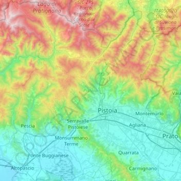
Name: Pistoia topographic map, elevation, terrain.
Location: Pistoia, Tuscany, Italy (43.78810 10.62092 44.16018 11.07148)
Average elevation: 530 m
Minimum elevation: 4 m
Maximum elevation: 1,932 m
Make a donation
Gear up for your next adventure:
As an Amazon Associate, this site earns from qualifying purchases at no extra cost to you.
Other topographic maps
Click on a map to view its topography, its elevation and its terrain.
Make a donation
Gear up for your next adventure:
As an Amazon Associate, this site earns from qualifying purchases at no extra cost to you.
Make a donation
Gear up for your next adventure:
As an Amazon Associate, this site earns from qualifying purchases at no extra cost to you.
Case Fonte al Cerro
Italy > Tuscany > Puntone di Scarlino > Case Fonte al Cerro
Average elevation: 36 m