
Make a donation
Gear up for your next adventure:
As an Amazon Associate, this site earns from qualifying purchases at no extra cost to you.
Galena Bay topographic map
Click on the map to display elevation.
Make a donation
Gear up for your next adventure:
As an Amazon Associate, this site earns from qualifying purchases at no extra cost to you.
About this map
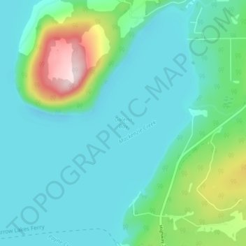
Name: Galena Bay topographic map, elevation, terrain.
Average elevation: 489 m
Minimum elevation: 417 m
Maximum elevation: 780 m
Make a donation
Gear up for your next adventure:
As an Amazon Associate, this site earns from qualifying purchases at no extra cost to you.
Other topographic maps
Click on a map to view its topography, its elevation and its terrain.
Trout Lake
Canada > British Columbia > Columbia-Shuswap Regional District > Area B (Shelter Bay/Mica Creek)
Average elevation: 823 m
Charity Peak
Canada > British Columbia > Columbia-Shuswap Regional District > Area B (Shelter Bay/Mica Creek)
Average elevation: 2,461 m
Faith Peak
Canada > British Columbia > Columbia-Shuswap Regional District > Area B (Shelter Bay/Mica Creek)
Average elevation: 2,349 m
Mount Begbie
Canada > British Columbia > Columbia-Shuswap Regional District > Area B (Shelter Bay/Mica Creek)
Average elevation: 2,066 m
Make a donation
Gear up for your next adventure:
As an Amazon Associate, this site earns from qualifying purchases at no extra cost to you.
Beaton
Canada > British Columbia > Columbia-Shuswap Regional District > Area B (Shelter Bay/Mica Creek)
Average elevation: 674 m
Selkirk Mountains
Canada > British Columbia > Columbia-Shuswap Regional District > Area B (Shelter Bay/Mica Creek)
Average elevation: 1,700 m
Bonney Glacier
Canada > British Columbia > Columbia-Shuswap Regional District > Area B (Shelter Bay/Mica Creek)
Average elevation: 2,295 m
Mount Mackenzie
Canada > British Columbia > Columbia-Shuswap Regional District > Area B (Shelter Bay/Mica Creek)
Average elevation: 1,975 m
Make a donation
Gear up for your next adventure:
As an Amazon Associate, this site earns from qualifying purchases at no extra cost to you.
Selkirk Mountains
Canada > British Columbia > Columbia-Shuswap Regional District > Area B (Shelter Bay/Mica Creek)
Average elevation: 1,700 m