
Shchetinovka topographic map
Interactive map
Click on the map to display elevation.
About this map
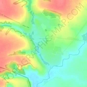
Name: Shchetinovka topographic map, elevation, terrain.
Average elevation: 183 m
Minimum elevation: 152 m
Maximum elevation: 218 m
Other topographic maps
Click on a map to view its topography, its elevation and its terrain.
Belgorod
Russia > Belgorod Oblast > Belgorodsky District
There were several attacks on Belgorod during the Russian invasion of Ukraine. Russian officials claimed that Belgorod was repeatedly targeted by indiscriminate Ukrainian attacks. On 1 April 2022, two Ukrainian Mi-24 performed a night raid and set fire to a fuel depot in Belgorod, in a low-altitude airstrike.…
Average elevation: 163 m