Geolocate

Ashley Junction topographic map

Click on the map to display elevation.

About this map

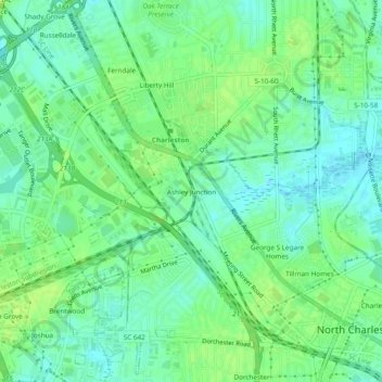
Name: Ashley Junction topographic map, elevation, terrain.

Location: Ashley Junction, North Charleston, Charleston County, South Carolina, 29405, United States (32.84906 -80.01564 32.88906 -79.97564)

Average elevation: 7 m

Minimum elevation: -2 m

Maximum elevation: 14 m

Other topographic maps

Click on a map to view its topography, its elevation and its terrain.

Gear up for your next adventure:

💧Hydration Reservoirs - Convenient water bladders for hands-free drinking on the move
🎒Hiking Daypacks (20L) - Compact backpacks for day trips and technical mountain ascents
🛌Sleeping Bags - Warm and packable sleeping bags for outdoor nights
🛰️Handheld GPS Devices - Reliable GPS units for hiking and outdoor navigation
🎒Hiking Child Carriers - Explore the outdoors with the whole family safely

As an Amazon Associate, this site earns from qualifying purchases at no extra cost to you.