Geolocate

Vétroz topographic map

Interactive map

Click on the map to display elevation.

About this map

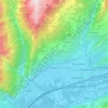
Name: Vétroz topographic map, elevation, terrain.

Location: Vétroz, Conthey, Wallis, 1963, Switzerland (46.19919 7.21925 46.26970 7.30197)

Average elevation: 920 m

Minimum elevation: 473 m

Maximum elevation: 2,285 m

Other topographic maps

Click on a map to view its topography, its elevation and its terrain.

Sornard

Switzerland > Wallis > Conthey

Average elevation: 1,026 m

Mont Fort

Switzerland > Wallis > Conthey > Nendaz

Average elevation: 2,892 m

Mordor

Switzerland > Wallis > Conthey > Conthey

Average elevation: 1,702 m

Mont Fort

Switzerland > Wallis > Conthey > Nendaz

Average elevation: 2,892 m

Baar (Nendaz)

Switzerland > Wallis > Conthey > Aproz

Average elevation: 832 m

Mayens de My

Switzerland > Wallis > Conthey > Conthey

Average elevation: 1,523 m