
Thank you for supporting this site ❤️
Make a donation
Make a donation
Gear up for your next adventure:
As an Amazon Associate, this site earns from qualifying purchases at no extra cost to you.
Pungsan-dong topographic map
Click on the map to display elevation.
Thank you for supporting this site ❤️
Make a donation
Make a donation
Gear up for your next adventure:
As an Amazon Associate, this site earns from qualifying purchases at no extra cost to you.
About this map
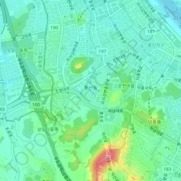
Name: Pungsan-dong topographic map, elevation, terrain.
Location: Pungsan-dong, 온천마을, Hanam-si, Gyeonggi, South Korea (37.53869 127.18134 37.56088 127.19899)
Average elevation: 34 m
Minimum elevation: 10 m
Maximum elevation: 111 m
Thank you for supporting this site ❤️
Make a donation
Make a donation
Gear up for your next adventure:
As an Amazon Associate, this site earns from qualifying purchases at no extra cost to you.