
Firnana topographic map
Interactive map
Click on the map to display elevation.
About this map
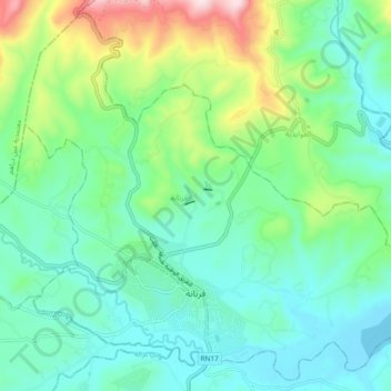
Name: Firnana topographic map, elevation, terrain.
Location: Firnana, معتمدية فرنانة, Jendouba, 8140, Tunisia (36.63901 8.65507 36.70941 8.74813)
Average elevation: 335 m
Minimum elevation: 213 m
Maximum elevation: 696 m
Other topographic maps
Click on a map to view its topography, its elevation and its terrain.
Aïn Draham
Tunisia > Jendouba > عين دراهم الأحواز
The city is the capital of a delegation of 40,372 inhabitants. The city itself has an estimated population of 10,843 inhabitants (according to the census of 2004). It is located at an altitude of 800 meters on the slopes of the Djebel Bir (1014 m), one of the Kroumirie mountains. The city is located in one of…
Average elevation: 574 m