
Thank you for supporting this site ❤️
Make a donation
Make a donation
Gear up for your next adventure:
As an Amazon Associate, this site earns from qualifying purchases at no extra cost to you.
Bärhäuser topographic map
Click on the map to display elevation.
Thank you for supporting this site ❤️
Make a donation
Make a donation
Gear up for your next adventure:
As an Amazon Associate, this site earns from qualifying purchases at no extra cost to you.
About this map
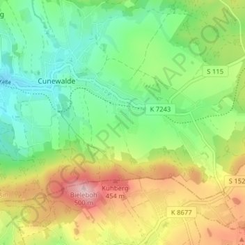
Name: Bärhäuser topographic map, elevation, terrain.
Location: Bärhäuser, Cunewalde, Bautzen, Sachsen, 02733, Deutschland (51.07168 14.51161 51.11168 14.55161)
Average elevation: 353 m
Minimum elevation: 266 m
Maximum elevation: 493 m
Thank you for supporting this site ❤️
Make a donation
Make a donation
Gear up for your next adventure:
As an Amazon Associate, this site earns from qualifying purchases at no extra cost to you.