
Cochorco topographic map
Interactive map
Click on the map to display elevation.
About this map
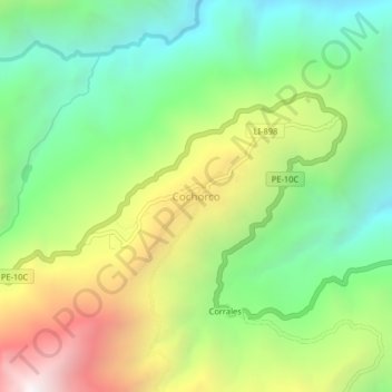
Name: Cochorco topographic map, elevation, terrain.
Location: Cochorco, Provincia de Sánchez Carrión, La Libertad, Perú (-7.82928 -77.70693 -7.78928 -77.66693)
Average elevation: 2,222 m
Minimum elevation: 1,520 m
Maximum elevation: 3,346 m
Other topographic maps
Click on a map to view its topography, its elevation and its terrain.
Cochorco
Perú > La Libertad > Cochorco
Cochorco, Provincia de Sánchez Carrión, La Libertad, Perú
Average elevation: 2,829 m