
Ottawa topographic map
Interactive map
Click on the map to display elevation.
About this map
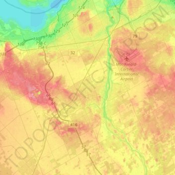
Name: Ottawa topographic map, elevation, terrain.
Location: Nepean, Ottawa, Eastern Ontario, Ontario, Kanada (45.18041 -75.92008 45.38794 -75.68889)
Average elevation: 93 m
Minimum elevation: 51 m
Maximum elevation: 130 m
Other topographic maps
Click on a map to view its topography, its elevation and its terrain.
Cumberland
Kanada > Ontario > Ottawa > Cumberland
Cumberland, Sheenboro Crescent, Fallingbrook, Orléans, Cumberland, Ottawa, Eastern Ontario, Ontario, K4A 3S1, Kanada
Average elevation: 75 m
Cumberland
Kanada > Ontario > Ottawa > Cumberland
Cumberland, Ottawa, Eastern Ontario, Ontario, Kanada
Average elevation: 75 m
Victoria Island
Victoria Island, (Old) Ottawa, Ottawa, Ontario, K1R 1C5, Kanada
Average elevation: 126 m