
Lorain topographic map
Interactive map
Click on the map to display elevation.
About this map
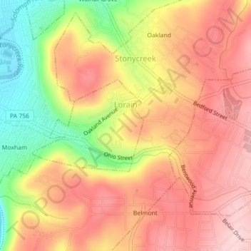
Name: Lorain topographic map, elevation, terrain.
Location: Lorain, Cambria County, Pennsylvania, United States (40.29177 -78.90545 40.30167 -78.88971)
Average elevation: 489 m
Minimum elevation: 356 m
Maximum elevation: 573 m
Other topographic maps
Click on a map to view its topography, its elevation and its terrain.
Saint Boniface
United States > Pennsylvania > Cambria County > Elder Township
Average elevation: 593 m
Beaver Valley
United States > Pennsylvania > Cambria County > Clearfield Township
Average elevation: 492 m
South Fork of the Little Conemaugh River
United States > Pennsylvania > Cambria County > Croyle Township > Rockville
Average elevation: 535 m
Saint Benedict
United States > Pennsylvania > Cambria County > West Carroll Township
Average elevation: 582 m