Geolocate

Las Pintitas topographic map

Interactive map

Click on the map to display elevation.

About this map

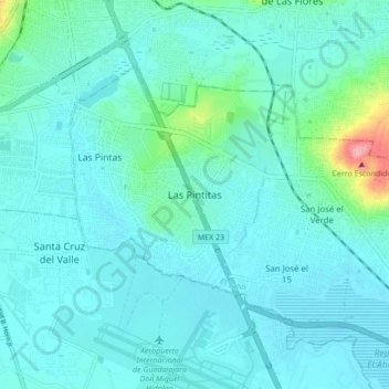
Name: Las Pintitas topographic map, elevation, terrain.

Location: Las Pintitas, El Salto, Región Centro, Jalisco, 45693, Mexico (20.51863 -103.34597 20.59863 -103.26597)

Average elevation: 1,539 m

Minimum elevation: 1,519 m

Maximum elevation: 1,670 m

Other topographic maps

Click on a map to view its topography, its elevation and its terrain.

Puerto Vallarta

Mexico > Jalisco > Puerto Vallarta

Fourth: In 1968 the Puerto Vallarta municipality was elevated to City status. The elevation in status reflected interest by Mexican federal and state governments in developing the Puerto Vallarta as an international resort destination. Puerto Vallarta has since also attracted a lively immigrant community from…

Average elevation: 306 m

Guadalajara

Mexico > Jalisco > Guadalajara

Average elevation: 1,572 m

Santa Ana Tepetitlán

Mexico > Jalisco > Zapopan

Average elevation: 1,723 m

Puente Grande

Mexico > Jalisco > Tonalá

Average elevation: 1,483 m

Puerto Vallarta

Mexico > Jalisco

Average elevation: 437 m

El Arenal

Mexico > Jalisco > El Arenal

Average elevation: 1,413 m

Ejutla

Mexico > Jalisco

Average elevation: 1,207 m

Zapotlanejo

Mexico > Jalisco

Average elevation: 1,648 m

Tequila

Mexico > Jalisco > Tequila

Tequila is one of the 124 municipalities of Jalisco, located just west of the center of the state. Its territory extends for 1689.11km2, with elevations that vary between 700 and 2,900 meters above sea level. The municipality borders with the main metropolitan region of Guadalajara to the east (Zapopan), and…

Average elevation: 1,267 m

Zacoalco de Torres

Mexico > Jalisco

Average elevation: 1,670 m

Ciudad Guzmán

Mexico > Jalisco > Zapotlán el Grande

Average elevation: 1,743 m

Colotlán

Mexico > Jalisco

Average elevation: 1,907 m

Zacatongo

Mexico > Jalisco > Mascota

Average elevation: 774 m

Arandas

Mexico > Jalisco

Arandas is situated on the Mesa Central at an elevation of 6,762 feet (2,061 metres). Arandas is commonly known among Mexicans as the commercial and manufacturing centre for agricultural products (typically beans and wheat) and its pastoral environment, which allows the city to produce various commercial…

Average elevation: 2,031 m

Colotitlán

Mexico > Jalisco > Tenamaxtlán

Average elevation: 1,412 m

Tlajomulco de Zúñiga

Mexico > Jalisco

Average elevation: 1,670 m

Río Blanco

Mexico > Jalisco > Zapopan

Average elevation: 1,575 m

Jocotepec

Mexico > Jalisco

Average elevation: 1,710 m

Chamela

Mexico > Jalisco > La Huerta

Average elevation: 32 m

El Grullo

Mexico > Jalisco

Average elevation: 1,041 m

Cabo Corrientes

Mexico > Jalisco

Cabo Corrientes is in the west of the state, on the Pacific Ocean. Elevations range from sea level to 1,085 metres (3,560 ft). The Bahía de Banderas is to the north, Puerto Vallarta to the northeast, Talpa de Allende to the east, Tomatlán to the south, and the Pacific Ocean to the west.

Average elevation: 348 m

Unión de Tula

Mexico > Jalisco

Average elevation: 1,411 m

Tepatitlán

Mexico > Jalisco > Tepatitlán de Morelos

Average elevation: 1,879 m

Melaque

Mexico > Jalisco > Cihuatlán

Average elevation: 38 m

Lake Chapala

Mexico > Jalisco > Chapala

Average elevation: 1,732 m

Valle de Guadalupe

Mexico > Jalisco

Average elevation: 1,873 m

San Patricio

Mexico > Jalisco > Cihuatlán

Average elevation: 12 m

Coyula

Mexico > Jalisco > Tonalá

Average elevation: 1,532 m

Lagos de Moreno

Mexico > Jalisco > Lagos de Moreno

Lagos de Moreno has a subtropical highland climate (Köppen climate classification Cwb) with mild temperatures year round. Temperatures are generally similar for any given month, but daily high and low fluctuations can be very sharp in the winter due in part to the city's altitude and its uneven surroundings.…

Average elevation: 1,956 m

Zapopan

Mexico > Jalisco

Most of the municipality is flat with another quarter having rolling hills. Altitude varies from 1,500 to 2,000 metres (4,900 to 6,600 ft) above sea level. The main elevations are in the Sierra de la Primavera and include Nejahuete, Tajo and El Chapulin. Superficial water flows mostly in arroyos east to the…

Average elevation: 1,586 m

Navidad

Mexico > Jalisco > Mascota

Average elevation: 1,964 m

El Salto

Mexico > Jalisco

Average elevation: 1,553 m

Guadalajara

Mexico > Jalisco

Under the Köppen climate classification, Guadalajara has a humid subtropical climate (Cwa) that is quite close to a tropical climate, featuring dry, warm winters and hot, wet summers. Guadalajara's climate is influenced by its high altitude and the general seasonality of precipitation patterns in western…

Average elevation: 1,543 m

San Juan de Ocotán

Mexico > Jalisco > Zapopan > San Juan de Ocotán

Average elevation: 1,666 m

Jalostotitlán

Mexico > Jalisco

Average elevation: 1,788 m

Ajijic

Mexico > Jalisco > Chapala

The Chapala Lake basin has a year-round average temperature of about 19 °C (66 °F). Due to Ajijic's tropical latitude and relatively high elevation, it is seldom unpleasantly hot or humid. The rainy season begins in June and lasts until October. The average rainfall is 793 millimetres (31.2 in). Even during…

Average elevation: 1,738 m

Milpillas

Mexico > Jalisco > Atotonilco el Alto > Milpillas

Average elevation: 1,590 m

Teocaltiche

Mexico > Jalisco > Teocaltiche

Average elevation: 1,855 m

Amatitán

Mexico > Jalisco > Amatitán

Average elevation: 1,242 m

Talpa de Allende

Mexico > Jalisco > Talpa de Allende

Average elevation: 1,130 m

El Tuito

Mexico > Jalisco > El Tuito

Average elevation: 697 m

Atemajac de Brizuela

Mexico > Jalisco

Average elevation: 2,014 m

Ameca

Mexico > Jalisco

Average elevation: 1,508 m

Chapala

Mexico > Jalisco > Chapala

Average elevation: 1,646 m

Tizapán el Alto

Mexico > Jalisco

Average elevation: 1,785 m

Tlaquepaque

Mexico > Jalisco > San Pedro Tlaquepaque

Average elevation: 1,562 m

Tonaya

Mexico > Jalisco

Average elevation: 1,361 m

El Arenal

Mexico > Jalisco

Average elevation: 1,456 m

El Rodeo

Mexico > Jalisco > El Rodeo

Average elevation: 1,529 m