
Castrelo do Val topographic map
Interactive map
Click on the map to display elevation.
About this map
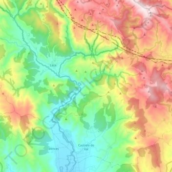
Name: Castrelo do Val topographic map, elevation, terrain.
Location: Castrelo do Val, Verín, Ourense, Galicia, Spain (41.97306 -7.46507 42.11190 -7.26736)
Average elevation: 764 m
Minimum elevation: 393 m
Maximum elevation: 1,353 m
Other topographic maps
Click on a map to view its topography, its elevation and its terrain.
As Ermitas
Spain > Galicia > Verín > Vilardevós
As Ermitas, Moialde, Vilardevós, Verín, Ourense, Galicia, 32610, Spain
Average elevation: 673 m
San Cibrao
Spain > Galicia > Verín > Oímbra
San Cibrao, Oímbra, Verín, Ourense, Galicia, Spain
Average elevation: 430 m