
Make a donation
Gear up for your next adventure:
As an Amazon Associate, this site earns from qualifying purchases at no extra cost to you.
Aaqoura topographic map
Click on the map to display elevation.
Make a donation
Gear up for your next adventure:
As an Amazon Associate, this site earns from qualifying purchases at no extra cost to you.
Aaqoura
Aqoura (Arabic: عاقورة, also spelled Aaqoura, "Akoura") is a mountainous village in the Byblos District of Keserwan-Jbeil Governorate, Lebanon. It is lovated 68 kilometers north of Beirut. Aaqoura has an average elevation of 1,600 meters above sea level (between 1000 and 2189 m) and a total land area of around 120 square kilometers . Aaqoura's inhabitants are Maronite Catholics and Aaqoura is considered to be the birth place of Maronitism and the origin of the overwhelming majority of all Lebanese Maronite families. Nature wise, Aaqoura is known to have one of the most breathtaking mountain chain in the world and is known to be very rich in water fountains and rivers and it is as well home to numerous caves, including the second (Rweiss) and fourth (Ain El Lebneh Grotto) deepest caves in Lebanon.
Make a donation
Gear up for your next adventure:
As an Amazon Associate, this site earns from qualifying purchases at no extra cost to you.
About this map
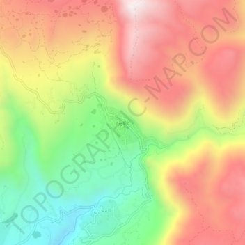
Name: Aaqoura topographic map, elevation, terrain.
Location: Aaqoura, Jbeil District, Keserwan-Jbeil Governorate, Lebanon (34.10118 35.88296 34.14118 35.92296)
Average elevation: 1,590 m
Minimum elevation: 1,046 m
Maximum elevation: 2,100 m
Make a donation
Gear up for your next adventure:
As an Amazon Associate, this site earns from qualifying purchases at no extra cost to you.
Other topographic maps
Click on a map to view its topography, its elevation and its terrain.
Faytroun
Lebanon > Keserwan-Jbeil Governorate
Faitroun (Arabic: فيطرون, romanized: Fayṭrūn; also spelled Faytroun) is a town in the Keserwan District of Keserwan-Jbeil Governorate. Located 33 kilometers north of Beirut and at an average altitude of 1,200 meters above sea level and its total land area of 743 hectares. Its inhabitants are…
Average elevation: 1,207 m
Make a donation
Gear up for your next adventure:
As an Amazon Associate, this site earns from qualifying purchases at no extra cost to you.
Make a donation
Gear up for your next adventure:
As an Amazon Associate, this site earns from qualifying purchases at no extra cost to you.
Make a donation
Gear up for your next adventure:
As an Amazon Associate, this site earns from qualifying purchases at no extra cost to you.
Make a donation
Gear up for your next adventure:
As an Amazon Associate, this site earns from qualifying purchases at no extra cost to you.
Make a donation
Gear up for your next adventure:
As an Amazon Associate, this site earns from qualifying purchases at no extra cost to you.
Make a donation
Gear up for your next adventure:
As an Amazon Associate, this site earns from qualifying purchases at no extra cost to you.
Mounsef
Lebanon > Keserwan-Jbeil Governorate
Mounsef (Arabic: المنصف, also spelled al-Mounsif) is a municipality in the Byblos District of Keserwan-Jbeil Governorate, Lebanon. It located off the Mediterranean coast and is 47 kilometers north of Beirut. Mounsef has an average elevation of 220 meters above sea level and a total land area of 341…
Average elevation: 127 m
Make a donation
Gear up for your next adventure:
As an Amazon Associate, this site earns from qualifying purchases at no extra cost to you.
Make a donation
Gear up for your next adventure:
As an Amazon Associate, this site earns from qualifying purchases at no extra cost to you.
Make a donation
Gear up for your next adventure:
As an Amazon Associate, this site earns from qualifying purchases at no extra cost to you.
Make a donation
Gear up for your next adventure:
As an Amazon Associate, this site earns from qualifying purchases at no extra cost to you.
Make a donation
Gear up for your next adventure:
As an Amazon Associate, this site earns from qualifying purchases at no extra cost to you.
Zouk Mosbeh
Lebanon > Keserwan-Jbeil Governorate
Zouk Mosbeh (Arabic: زوق مصبح) is a town and municipality in the Keserwan District of the Keserwan-Jbeil Governorate in Lebanon. It is located 12 kilometers north of Beirut. Zouk Mosbeh's average elevation is 170 meters above sea level and its total land area is 453 hectares. Its inhabitants are…
Average elevation: 114 m
Make a donation
Gear up for your next adventure:
As an Amazon Associate, this site earns from qualifying purchases at no extra cost to you.
Make a donation
Gear up for your next adventure:
As an Amazon Associate, this site earns from qualifying purchases at no extra cost to you.
Ghazir
Lebanon > Keserwan-Jbeil Governorate
Ghazir (Arabic: غزير) is a town and municipality in the Keserwan District of the Keserwan-Jbeil Governorate of Lebanon. It is located 27 kilometres (17 mi) north of Beirut. It has an average elevation of 380 meters above sea level and a total land area of 542 hectares (2.09 sq mi). The town has four…
Average elevation: 359 m
Make a donation
Gear up for your next adventure:
As an Amazon Associate, this site earns from qualifying purchases at no extra cost to you.
Make a donation
Gear up for your next adventure:
As an Amazon Associate, this site earns from qualifying purchases at no extra cost to you.