
Make a donation
Gear up for your next adventure:
As an Amazon Associate, this site earns from qualifying purchases at no extra cost to you.
Lembang topographic map
Click on the map to display elevation.
Make a donation
Gear up for your next adventure:
As an Amazon Associate, this site earns from qualifying purchases at no extra cost to you.
About this map
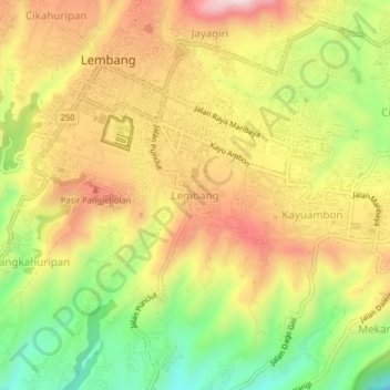
Name: Lembang topographic map, elevation, terrain.
Location: Lembang, West Bandung, West Java, Java, 40391, Indonesia (-6.84504 107.60610 -6.80504 107.64610)
Average elevation: 1,189 m
Minimum elevation: 959 m
Maximum elevation: 1,401 m
Make a donation
Gear up for your next adventure:
As an Amazon Associate, this site earns from qualifying purchases at no extra cost to you.
Other topographic maps
Click on a map to view its topography, its elevation and its terrain.
Ir. H. Juanda Grand Forest Park
Indonesia > West Java > West Bandung > Langensari
Average elevation: 1,101 m
Make a donation
Gear up for your next adventure:
As an Amazon Associate, this site earns from qualifying purchases at no extra cost to you.
DUSUN PALASARI DESA CINTA ASIH KC. CIPONGKOR KAB. BANDUNG BARAT
Indonesia > West Java > West Bandung
Average elevation: 1,013 m
Outbond Ciwangun Indah Camp
Indonesia > West Java > West Bandung > Kertawangi
Average elevation: 1,447 m