
Make a donation
Gear up for your next adventure:
As an Amazon Associate, this site earns from qualifying purchases at no extra cost to you.
Kapuas River topographic map
Click on the map to display elevation.
Make a donation
Gear up for your next adventure:
As an Amazon Associate, this site earns from qualifying purchases at no extra cost to you.
Kapuas River
The river originates near the center of Borneo, south of the Indonesian-Malaysian border, in the joint between the western slope of the Müller Mountain Range, which runs through the island center, and the southern slope of the Upper Kapuas Range (Indonesian: Kapuas Hulu), which is located more to the west. For about 165 km (103 mi) it flows through a mountainous terrain and then descends to a marshy plain. There, the elevation decreases by only 50 meters (160 ft) over 900 km (560 mi) from Putussibau to the river delta. About 350 km (220 mi) from the source, near the northern shore of the river, lies a system of Kapuas Lakes which are connected to the river by numerous channels. These lakes are Bekuan (area 1,268 hectares), Belida (600 ha), Genali (2,000 ha), Keleka Tangai (756 ha), Luar (5,208 ha), Pengembung (1,548 ha), Sambor (673 ha), Sekawi (672 ha), Sentarum (2,324 ha), Sependan (604 ha), Seriang (1,412) Sumbai (800 ha), Sumpa (664) and Tekenang (1,564 ha). When the monthly precipitation exceeds about 300 mm (12 in), the river overflows its banks, diverting much of its waters to the lakes at a rate of up to 1,000 m3/s (35,000 cu ft/s), and forming a single volume of water with them. This outflow prevents massive flooding of the lower reaches of the river; it also promotes fish migration from the river to the lakes for spawning, but drives birds away from the lakes.
Make a donation
Gear up for your next adventure:
As an Amazon Associate, this site earns from qualifying purchases at no extra cost to you.
About this map
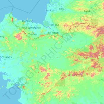
Name: Kapuas River topographic map, elevation, terrain.
Location: Kapuas River, Kalimantan, Indonesia (-0.39902 109.08428 1.00356 113.63732)
Average elevation: 141 m
Minimum elevation: -4 m
Maximum elevation: 1,992 m
Make a donation
Gear up for your next adventure:
As an Amazon Associate, this site earns from qualifying purchases at no extra cost to you.
Other topographic maps
Click on a map to view its topography, its elevation and its terrain.
Make a donation
Gear up for your next adventure:
As an Amazon Associate, this site earns from qualifying purchases at no extra cost to you.
Make a donation
Gear up for your next adventure:
As an Amazon Associate, this site earns from qualifying purchases at no extra cost to you.
Make a donation
Gear up for your next adventure:
As an Amazon Associate, this site earns from qualifying purchases at no extra cost to you.
Make a donation
Gear up for your next adventure:
As an Amazon Associate, this site earns from qualifying purchases at no extra cost to you.
Make a donation
Gear up for your next adventure:
As an Amazon Associate, this site earns from qualifying purchases at no extra cost to you.
Make a donation
Gear up for your next adventure:
As an Amazon Associate, this site earns from qualifying purchases at no extra cost to you.
Ungaran
Indonesia > Central Java > Kabupaten Semarang
Ungaran (Dutch: Oengaran) is a town and adjacent areas in Central Java Province of Indonesia. The town serves as the administrative centre of the Semarang Regency in that province. Ungaran is located at -7° 8' 17", 110° 24' 18" at an elevation of 319 metres. It encompasses two districts (kecamatan) within…
Average elevation: 399 m
Make a donation
Gear up for your next adventure:
As an Amazon Associate, this site earns from qualifying purchases at no extra cost to you.
Make a donation
Gear up for your next adventure:
As an Amazon Associate, this site earns from qualifying purchases at no extra cost to you.
Make a donation
Gear up for your next adventure:
As an Amazon Associate, this site earns from qualifying purchases at no extra cost to you.
Make a donation
Gear up for your next adventure:
As an Amazon Associate, this site earns from qualifying purchases at no extra cost to you.
Make a donation
Gear up for your next adventure:
As an Amazon Associate, this site earns from qualifying purchases at no extra cost to you.
Make a donation
Gear up for your next adventure:
As an Amazon Associate, this site earns from qualifying purchases at no extra cost to you.
Make a donation
Gear up for your next adventure:
As an Amazon Associate, this site earns from qualifying purchases at no extra cost to you.
Make a donation
Gear up for your next adventure:
As an Amazon Associate, this site earns from qualifying purchases at no extra cost to you.
Make a donation
Gear up for your next adventure:
As an Amazon Associate, this site earns from qualifying purchases at no extra cost to you.
Rinjani
Indonesia > West Nusa Tenggara
In September 1995 an aviation report was issued concerning an unconfirmed ash cloud from Rinjani. A NOTAM about volcanic activity from Rinjani was issued by the Bali Flight Information Region on the morning of 12 September. An ash cloud was reportedly drifting to the south west with the cloud top around 4 km…
Average elevation: 3,071 m
Make a donation
Gear up for your next adventure:
As an Amazon Associate, this site earns from qualifying purchases at no extra cost to you.
Petung
Indonesia > Special Region of Yogyakarta > Sleman Regency > Cangkringan
Average elevation: 864 m
Make a donation
Gear up for your next adventure:
As an Amazon Associate, this site earns from qualifying purchases at no extra cost to you.
Bandung
Bandung (Sundanese: ᮘᮔ᮪ᮓᮥᮀ, romanized: Bandung, Sundanese pronunciation: [ˈbandʊŋ]; /ˈbɑːndʊŋ/) is the capital city of the Indonesian province of West Java. It has a population of 2,452,943 within its city limits according to the official estimates as at mid 2021, making it the fourth most…
Average elevation: 893 m
Make a donation
Gear up for your next adventure:
As an Amazon Associate, this site earns from qualifying purchases at no extra cost to you.
Make a donation
Gear up for your next adventure:
As an Amazon Associate, this site earns from qualifying purchases at no extra cost to you.
Make a donation
Gear up for your next adventure:
As an Amazon Associate, this site earns from qualifying purchases at no extra cost to you.
Make a donation
Gear up for your next adventure:
As an Amazon Associate, this site earns from qualifying purchases at no extra cost to you.
Make a donation
Gear up for your next adventure:
As an Amazon Associate, this site earns from qualifying purchases at no extra cost to you.
Make a donation
Gear up for your next adventure:
As an Amazon Associate, this site earns from qualifying purchases at no extra cost to you.
Sidorejo
Indonesia > Special Region of Yogyakarta > Sleman Regency > Cangkringan
Average elevation: 874 m
Puncak Jaya
Indonesia > Central Papua > Mimika
Puncak Jaya (Indonesian: [ˈpuntʃak ˈdʒaja]; literally "Glorious Peak", Amungme: Nemangkawi Ninggok) or Carstensz Pyramid (/ˈkɑːrstəns/, Indonesian: Piramida Carstensz, Dutch: Carstenszpiramide) on the island of New Guinea, with an elevation of 4,884 m (16,024 ft), is the highest mountain peak of an…
Average elevation: 4,271 m
Make a donation
Gear up for your next adventure:
As an Amazon Associate, this site earns from qualifying purchases at no extra cost to you.
Make a donation
Gear up for your next adventure:
As an Amazon Associate, this site earns from qualifying purchases at no extra cost to you.