
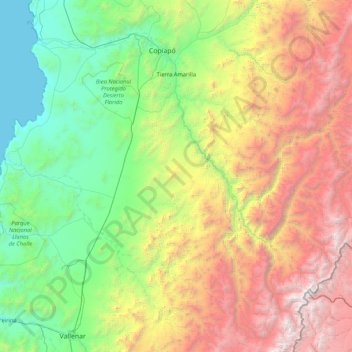
Tierra Amarilla topographic map
Interactive map
Click on the map to display elevation.
About this map
Name: Tierra Amarilla topographic map, elevation, terrain.
Average elevation: 1,719 m
Minimum elevation: 0 m
Maximum elevation: 5,769 m
Other topographic maps
Click on a map to view its topography, its elevation and its terrain.
Bahía Inglesa
Chile > Atacama Region > Provincia de Copiapó > Caldera
Bahia Inglesa ("English Bay") is a locality located near the port of Caldera in Atacama Region, Chile. It is situated at an average elevation of 10 meters above the sea level. As of 2017, it had a population of 535.
Average elevation: 10 m
Nevado Ojos del Salado
Chile > Atacama Region > Provincia de Copiapó > Copiapó
Nevado Ojos del Salado is a dormant complex volcano in the Andes on the Argentina–Chile border. It is the highest volcano on Earth and the highest peak in Chile. The upper reaches of Ojos del Salado consist of several overlapping lava domes, lava flows and volcanic craters, with sparse ice cover. The complex…
Average elevation: 6,446 m