
A l'Hermitage topographic map
Interactive map
Click on the map to display elevation.
About this map
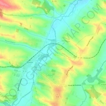
Name: A l'Hermitage topographic map, elevation, terrain.
Average elevation: 172 m
Minimum elevation: 139 m
Maximum elevation: 221 m
Other topographic maps
Click on a map to view its topography, its elevation and its terrain.
Aux Matalines
France > Occitanie > Gers > Gimont > Aux Matalines
Aux Matalines, Gimont, Auch, Gers, Occitanie, France métropolitaine, 32200, France
Average elevation: 176 m