
Llanbedr topographic map
Interactive map
Click on the map to display elevation.
About this map
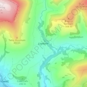
Name: Llanbedr topographic map, elevation, terrain.
Location: Llanbedr, Powys, Wales, NP8 1SQ, United Kingdom (51.85650 -3.12637 51.89650 -3.08637)
Average elevation: 283 m
Minimum elevation: 81 m
Maximum elevation: 699 m
Other topographic maps
Click on a map to view its topography, its elevation and its terrain.
Llanbedr
United Kingdom > Wales > Llanbedr
Llanbedr, Gwynedd, Wales, LL45 2LD, United Kingdom
Average elevation: 56 m