
Goderich topographic map
Interactive map
Click on the map to display elevation.
About this map
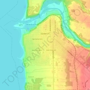
Name: Goderich topographic map, elevation, terrain.
Location: Goderich, Huron County, Ontario, Canada (43.72074 -81.74225 43.75475 -81.68458)
Average elevation: 204 m
Minimum elevation: 171 m
Maximum elevation: 245 m
Other topographic maps
Click on a map to view its topography, its elevation and its terrain.
Exeter
Canada > Ontario > Huron County > South Huron
Exeter, South Huron, Huron County, Ontario, N0M 1S1, Canada
Average elevation: 268 m