
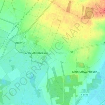
Groß Schwarzlosen topographic map
Interactive map
Click on the map to display elevation.
About this map
Name: Groß Schwarzlosen topographic map, elevation, terrain.
Average elevation: 52 m
Minimum elevation: 33 m
Maximum elevation: 88 m
Other topographic maps
Click on a map to view its topography, its elevation and its terrain.
Weißewarte
Deutschland > Sachsen-Anhalt > Tangerhütte > Weißewarte
Weißewarte, Tangerhütte, Stendal, Sachsen-Anhalt, Deutschland
Average elevation: 37 m
Kehnert
Deutschland > Sachsen-Anhalt > Tangerhütte
Kehnert, Tangerhütte, Stendal, Sachsen-Anhalt, Deutschland
Average elevation: 43 m
Stegelitz
Deutschland > Sachsen-Anhalt > Tangerhütte
Stegelitz, Tangerhütte, Stendal, Sachsen-Anhalt, Deutschland
Average elevation: 40 m