
Thank you for supporting this site ❤️
Make a donation
Make a donation
Gear up for your next adventure:
As an Amazon Associate, this site earns from qualifying purchases at no extra cost to you.
Vorstadt topographic map
Click on the map to display elevation.
Thank you for supporting this site ❤️
Make a donation
Make a donation
Gear up for your next adventure:
As an Amazon Associate, this site earns from qualifying purchases at no extra cost to you.
About this map
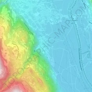
Name: Vorstadt topographic map, elevation, terrain.
Average elevation: 413 m
Minimum elevation: 245 m
Maximum elevation: 997 m
Thank you for supporting this site ❤️
Make a donation
Make a donation
Gear up for your next adventure:
As an Amazon Associate, this site earns from qualifying purchases at no extra cost to you.
Other topographic maps
Click on a map to view its topography, its elevation and its terrain.
Mayenburg
Italien > Trentino-Südtirol > Bozen > Völlan
Die Mayenburg, auch Maienburg und Maienberg, ist die Ruine einer Höhenburg auf einem langgestreckten Hügel nahe Völlan, einer Fraktion der Marktgemeinde Lana in Südtirol.
Average elevation: 665 m