Geolocate

Lochearnhead topographic map

Click on the map to display elevation.

About this map

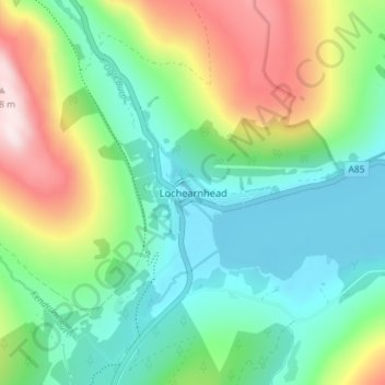
Name: Lochearnhead topographic map, elevation, terrain.

Location: Lochearnhead, Stirling, Scotland, FK19 8PR, United Kingdom (56.36674 -4.30461 56.40674 -4.26461)

Average elevation: 274 m

Minimum elevation: 93 m

Maximum elevation: 670 m

Stirling trails, hiking, mountain biking, running and outdoor activities

Other topographic maps

Click on a map to view its topography, its elevation and its terrain.

Loch Earn

United Kingdom > Scotland > Stirling > Lochearnhead

Average elevation: 393 m

Glen Ogle

United Kingdom > Scotland > Stirling > Lochearnhead

Average elevation: 463 m

Gear up for your next adventure:

👕Technical Hiking Tees - Moisture-management for high-exertion climbs
🐕Dog Hiking Gear - Equipment for hiking safely with dogs
👟Heavy Duty Boot Laces - Always carry a spare for your hiking footwear
🍱Food Containers - Reusable containers for outdoor meals
🎒Hiking Daypacks (20L) - Compact backpacks for day trips and technical mountain ascents

As an Amazon Associate, this site earns from qualifying purchases at no extra cost to you.