
برج السدرية topographic map
Interactive map
Click on the map to display elevation.
About this map
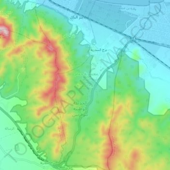
Name: برج السدرية topographic map, elevation, terrain.
Location: برج السدرية, معتمدية حمام الشط, Ben Arous, Tunisia (36.64482 10.36116 36.71761 10.41874)
Average elevation: 156 m
Minimum elevation: -1 m
Maximum elevation: 550 m
Other topographic maps
Click on a map to view its topography, its elevation and its terrain.
بومهل البساتين
Tunisia > Ben Arous > بومهل البساتين
بومهل البساتين, بومهل, معتمدية بومهل البساتين, Ben Arous, 2097, Tunisia
Average elevation: 47 m