Geolocate

Wichling topographic map

Click on the map to display elevation.

About this map

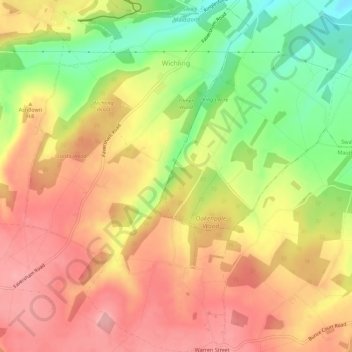
Name: Wichling topographic map, elevation, terrain.

Location: Wichling, Maidstone, Kent, England, United Kingdom (51.24428 0.72871 51.27931 0.76451)

Average elevation: 148 m

Minimum elevation: 76 m

Maximum elevation: 198 m

Kent trails, hiking, mountain biking, running and outdoor activities

Other topographic maps

Click on a map to view its topography, its elevation and its terrain.

Westfield Sole

United Kingdom > England > Kent > Maidstone

Average elevation: 145 m

Detling Hill

United Kingdom > England > Kent > Maidstone

Average elevation: 152 m

Mote Park

United Kingdom > England > Kent > Maidstone > Otham

Average elevation: 52 m

Broomfield

United Kingdom > England > Kent > Maidstone > Leeds

Average elevation: 96 m

Lenham Heath

United Kingdom > England > Kent > Maidstone

Average elevation: 96 m

Leadingcross Green

United Kingdom > England > Kent > Maidstone > Lenham

Average elevation: 118 m

Walderslade Woods

United Kingdom > England > Kent > Maidstone

Average elevation: 155 m

Harpole

United Kingdom > England > Kent > Maidstone > Detling

Average elevation: 103 m

Bletchenden

United Kingdom > England > Kent > Maidstone > Headcorn

Average elevation: 24 m

Liverton Street

United Kingdom > England > Kent > Maidstone > Grafty Green

Average elevation: 102 m

Linton

United Kingdom > England > Kent > Maidstone

Average elevation: 71 m

East Lenham

United Kingdom > England > Kent > Maidstone > Lenham

Average elevation: 127 m

Bicknor Wood

United Kingdom > England > Kent > Maidstone > Otham

Average elevation: 85 m

Laddingford

United Kingdom > England > Kent > Maidstone > Yalding

Average elevation: 14 m

Langley Park

United Kingdom > England > Kent > Maidstone > Langley

Average elevation: 96 m

Bletchingly

United Kingdom > England > Kent > Maidstone

Average elevation: 37 m

Weavering Park

United Kingdom > England > Kent > Maidstone > Grove Green

Average elevation: 56 m

Kingswood

United Kingdom > England > Kent > Maidstone

Average elevation: 109 m

Gear up for your next adventure:

🧵Survival Paracord - Multi-purpose cordage for emergency repairs and shelters
🧦Hiking Socks - Breathable socks designed to prevent blisters on long walks
📱Phone Mounts for Hiking - Secure mounts to carry your phone on trails
👖Hiking Trousers - Durable trousers designed for rough terrain
❄️Walking Crampons - Added traction for icy slopes and winter peak bagging

As an Amazon Associate, this site earns from qualifying purchases at no extra cost to you.