Geolocate

Rouyn topographic map

Click on the map to display elevation.

About this map
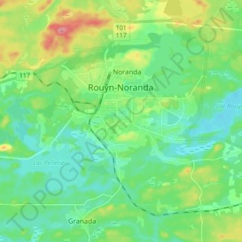
Name: Rouyn topographic map, elevation, terrain.

Location: Rouyn, Rouyn-Noranda, Abitibi-Témiscamingue, Quebec, Canada (48.20605 -79.08351 48.25356 -78.95222)

Average elevation: 297 m

Minimum elevation: 267 m

Maximum elevation: 373 m

Other topographic maps

Click on a map to view its topography, its elevation and its terrain.
Rollet

Canada > Quebec > Rouyn-Noranda

Average elevation: 276 m

Lac Labyrinthe

Canada > Quebec > Rouyn-Noranda

Average elevation: 291 m

Lac Brunet

Canada > Quebec > Rouyn-Noranda

Average elevation: 391 m

Gear up for your next adventure:

🧥Breathable Waterproof Jackets - Essential rain protection for the unpredictable British climate
🧴Tick Removal Tools - Small, essential health tool for UK woodland and moorland
🔥Emergency Fire Starters - Reliable ignition tools for survival situations in damp conditions
🧤Hiking Gloves - Warm and durable gloves for cold-weather walks
🛑Emergency Bivvy Bags - Heat-reflective survival bags for unexpected nights out

As an Amazon Associate, this site earns from qualifying purchases at no extra cost to you.