
Make a donation
Gear up for your next adventure:
As an Amazon Associate, this site earns from qualifying purchases at no extra cost to you.
Tenextepango topographic map
Click on the map to display elevation.
Make a donation
Gear up for your next adventure:
As an Amazon Associate, this site earns from qualifying purchases at no extra cost to you.
Tenextepango
La localidad de Tenextepango está situado en el Municipio de Ayala, Estado de Morelos, en la latitud 18° 43′ 43.18″ N, longitud 98° 57′ 20.52″ W, a 1146 metros de altitud sobre el nivel del mar.
Make a donation
Gear up for your next adventure:
As an Amazon Associate, this site earns from qualifying purchases at no extra cost to you.
About this map
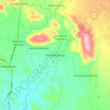
Name: Tenextepango topographic map, elevation, terrain.
Location: Tenextepango, Ayala, Morelos, 62725, México (18.68891 -98.99759 18.76891 -98.91759)
Average elevation: 1,196 m
Minimum elevation: 1,079 m
Maximum elevation: 1,436 m
Make a donation
Gear up for your next adventure:
As an Amazon Associate, this site earns from qualifying purchases at no extra cost to you.
Other topographic maps
Click on a map to view its topography, its elevation and its terrain.