
Make a donation
Gear up for your next adventure:
As an Amazon Associate, this site earns from qualifying purchases at no extra cost to you.
Lles topographic map
Click on the map to display elevation.
Make a donation
Gear up for your next adventure:
As an Amazon Associate, this site earns from qualifying purchases at no extra cost to you.
About this map
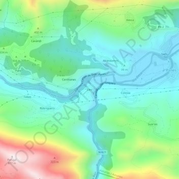
Name: Lles topographic map, elevation, terrain.
Location: Lles, Peñamellera Baja, Asturias, 33570, España (43.29907 -4.62904 43.33907 -4.58904)
Average elevation: 249 m
Minimum elevation: 15 m
Maximum elevation: 858 m
Make a donation
Gear up for your next adventure:
As an Amazon Associate, this site earns from qualifying purchases at no extra cost to you.
Other topographic maps
Click on a map to view its topography, its elevation and its terrain.
Panes
España > Asturias > Peñamellera Baja
La villa de Panes, es la capital del concejo y está situada a una altitud media de 50 metros.
Average elevation: 289 m
Make a donation
Gear up for your next adventure:
As an Amazon Associate, this site earns from qualifying purchases at no extra cost to you.