
Make a donation
Gear up for your next adventure:
As an Amazon Associate, this site earns from qualifying purchases at no extra cost to you.
Guardo topographic map
Click on the map to display elevation.
Make a donation
Gear up for your next adventure:
As an Amazon Associate, this site earns from qualifying purchases at no extra cost to you.
Guardo
Guardo's average elevation is 1123 metres above sea level. The majority of the town is modern, mainly constructed during the first half of the 20th century, although there is a small historic section on a hill to the east. The centre of the town is on the left bank of the river. The right bank contains the railway and industrial facilities, many of which are no longer in operation.
Make a donation
Gear up for your next adventure:
As an Amazon Associate, this site earns from qualifying purchases at no extra cost to you.
About this map
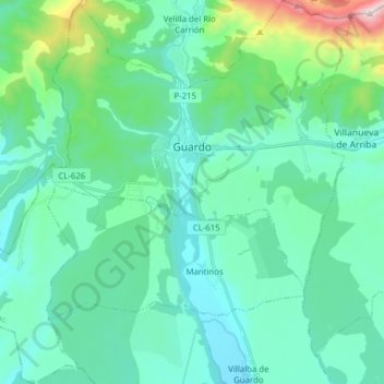
Name: Guardo topographic map, elevation, terrain.
Location: Guardo, Palencia, Castile and León, 34880, Spain (42.71879 -4.93636 42.83300 -4.78186)
Average elevation: 1,198 m
Minimum elevation: 1,039 m
Maximum elevation: 1,973 m
Make a donation
Gear up for your next adventure:
As an Amazon Associate, this site earns from qualifying purchases at no extra cost to you.