
Make a donation
Gear up for your next adventure:
As an Amazon Associate, this site earns from qualifying purchases at no extra cost to you.
Guaviare topographic map
Click on the map to display elevation.
Make a donation
Gear up for your next adventure:
As an Amazon Associate, this site earns from qualifying purchases at no extra cost to you.
About this map
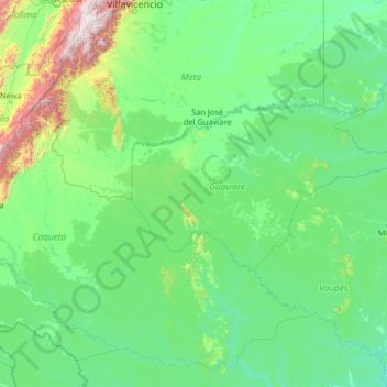
Name: Guaviare topographic map, elevation, terrain.
Location: Guaviare, Colombia (-0.91056 -75.42029 4.28944 -70.22029)
Average elevation: 345 m
Minimum elevation: 83 m
Maximum elevation: 4,079 m
Make a donation
Gear up for your next adventure:
As an Amazon Associate, this site earns from qualifying purchases at no extra cost to you.
Other topographic maps
Click on a map to view its topography, its elevation and its terrain.
Bogota
Colombia > Bogota, Capital District
Bogotá is located in the southeastern part of the Bogotá savanna (Sabana de Bogotá) at an average altitude of 2,640 meters (8,660 ft) above sea level. The Bogotá savanna is popularly called "savannah" (sabana), but constitutes actually a high plateau in the Andes mountains, part of an extended region known…
Average elevation: 2,711 m
Bogota
Colombia > Bogota, Capital District
The city is located in the center of Colombia, on a high plateau known as the Bogotá savanna, part of the Altiplano Cundiboyacense located in the Eastern Cordillera of the Andes. Its altitude averages 2,640 meters (8,660 ft) above sea level. Subdivided into 20 localities, Bogotá covers an area of 1,587…
Average elevation: 2,711 m
Antioquia
Due to its geographical isolation (as it is located among mountains), Antioquia suffered supply problems. Its topography did not allow for much agriculture, so the city became dependent upon trade, especially of gold and gin for the colonization of new land. Much of this trade was due to reforms passed after a…
Average elevation: 608 m
Make a donation
Gear up for your next adventure:
As an Amazon Associate, this site earns from qualifying purchases at no extra cost to you.
Bogota
Colombia > Bogota, Capital District
Bogotá is located in the southeastern part of the Bogotá savanna (Sabana de Bogotá) at an average altitude of 2,640 meters (8,660 ft) above sea level. The Bogotá savanna is popularly called "savannah" (sabana), but constitutes actually a high plateau in the Andes mountains, part of an extended region known…
Average elevation: 2,711 m
Make a donation
Gear up for your next adventure:
As an Amazon Associate, this site earns from qualifying purchases at no extra cost to you.
Cali
Colombia > Valle del Cauca > Cali
Under Köppen's climate classification, Cali features a dry-summer tropical monsoon climate (Köppen climate classification: Am), bordering a tropical savanna climate (Köppen: As). The Western Mountain Range rises from an average of 2,000 m (6,562 ft) above sea level in the northern part of the city to…
Average elevation: 1,140 m
Nemocón
The municipality is situated in the northern part of the Bogotá savanna, part of the Altiplano Cundiboyacense with its urban centre at an altitude of 2,585 metres (8,481 ft) and 65 kilometres (40 mi) from the capital Bogotá. Nemocón is the northeasternmost municipality of the Metropolitan Area of Bogotá…
Average elevation: 2,708 m
Make a donation
Gear up for your next adventure:
As an Amazon Associate, this site earns from qualifying purchases at no extra cost to you.
Concepción
Concepción has a cool tropical rainforest climate (Af) due to altitude. It has very heavy rainfall year-round.
Average elevation: 2,024 m
Medellín
Medellín has 16 comunas (districts), 5 corregimientos (townships), and 271 barrios (neighborhoods). The metropolitan area of Medellín lies within the Aburrá valley at an elevation of 1,500 meters (4,900 feet) above sea level and is bisected by the Medellín River (also called Porce), which flows northward.…
Average elevation: 2,071 m
Make a donation
Gear up for your next adventure:
As an Amazon Associate, this site earns from qualifying purchases at no extra cost to you.
Ciénaga La Popa
Colombia > Antioquia > Yondó > San Miguel del Tigre > El Tigre
Average elevation: 72 m
Make a donation
Gear up for your next adventure:
As an Amazon Associate, this site earns from qualifying purchases at no extra cost to you.
Bogota Capital District - Municipality
The city is located in the center of Colombia, on a high plateau known as the Bogotá savanna, part of the Altiplano Cundiboyacense located in the Eastern Cordillera of the Andes. Its altitude averages 2,640 meters (8,660 ft) above sea level, making it the third highest capital city in the world. Subdivided…
Average elevation: 2,135 m
Fusagasugá
It was founded in 1592 by Spanish priests. The town located some 56 kilometers from the capital, Bogotá; borders Pasca, Arbeláez, Tibacuy, Silvania and other municipalities of Sumapaz. Its elevation is 5,669 feet (1,728 m) above sea level, and the average temperature 20 °C (68 °F).
Average elevation: 2,109 m
Make a donation
Gear up for your next adventure:
As an Amazon Associate, this site earns from qualifying purchases at no extra cost to you.
Villa de Leyva
Located away from major trade routes in a high altitude valley of semi-desert terrain, and with no mineral deposits nearby to exploit, the town has undergone little development in the last 400 years. As a consequence, it is one of the few towns in Colombia to have preserved completely its original colonial…
Average elevation: 2,416 m
Make a donation
Gear up for your next adventure:
As an Amazon Associate, this site earns from qualifying purchases at no extra cost to you.
Make a donation
Gear up for your next adventure:
As an Amazon Associate, this site earns from qualifying purchases at no extra cost to you.
Make a donation
Gear up for your next adventure:
As an Amazon Associate, this site earns from qualifying purchases at no extra cost to you.
Bogota
Colombia > Bogota, Capital District
The city is located in the center of Colombia, on a high plateau known as the Bogotá savanna, part of the Altiplano Cundiboyacense located in the Eastern Cordillera of the Andes. Its altitude averages 2,640 meters (8,660 ft) above sea level, making it the third highest capital city in the world. Subdivided…
Average elevation: 2,712 m
Make a donation
Gear up for your next adventure:
As an Amazon Associate, this site earns from qualifying purchases at no extra cost to you.
Make a donation
Gear up for your next adventure:
As an Amazon Associate, this site earns from qualifying purchases at no extra cost to you.
Bogota
Colombia > Bogota, Capital District
The city is located in the center of Colombia, on a high plateau known as the Bogotá savanna, part of the Altiplano Cundiboyacense located in the Eastern Cordillera of the Andes. Its altitude averages 2,640 meters (8,660 ft) above sea level, making it the third highest capital city in the world. Subdivided…
Average elevation: 2,711 m
Medellín
Medellín has 16 comunas (districts), 5 corregimientos (townships), and 271 barrios (neighborhoods). The metropolitan area of Medellín lies within the Aburrá valley at an elevation of 1,500 meters (4,900 feet) above sea level and is bisected by the Medellín River (also called Porce), which flows northward.…
Average elevation: 2,071 m
Bucaramanga
Bucaramanga is located on a plateau in the Cordillera Oriental of the Colombian Andes, and many residents occupy unstable lands descending steeply from the meseta. Westbound of it, the Rio de Oro Canyon is located at an altitude of 600 metres (2,000 ft) above sea level. Eastbound, the Andean Range rises up in…
Average elevation: 1,268 m
Make a donation
Gear up for your next adventure:
As an Amazon Associate, this site earns from qualifying purchases at no extra cost to you.
Fusagasugá
It was founded in 1592 by Spanish priests. The town located some 56 kilometers from the capital, Bogotá; borders Pasca, Arbeláez, Tibacuy, Silvania and other municipalities of Sumapaz. Its elevation is 5,669 feet (1,728 m) above sea level, and the average temperature 20 °C (68 °F).
Average elevation: 2,109 m
Make a donation
Gear up for your next adventure:
As an Amazon Associate, this site earns from qualifying purchases at no extra cost to you.
Bogota, Capital District
The city is located in the center of Colombia, on a high plateau known as the Bogotá savanna, part of the Altiplano Cundiboyacense located in the Eastern Cordillera of the Andes. Its altitude averages 2,640 meters (8,660 ft) above sea level, making it the third highest capital city in the world. Subdivided…
Average elevation: 2,183 m
Bogota Capital District - Municipality
The city is located in the center of Colombia, on a high plateau known as the Bogotá savanna, part of the Altiplano Cundiboyacense located in the Eastern Cordillera of the Andes. Its altitude averages 2,640 meters (8,660 ft) above sea level, making it the third highest capital city in the world. Subdivided…
Average elevation: 2,135 m
Make a donation
Gear up for your next adventure:
As an Amazon Associate, this site earns from qualifying purchases at no extra cost to you.
Gachantivá
Gachantivá is a town and municipality in the Ricaurte Province, part of the Colombian department of Boyacá. Gachantivá is located at altitudes ranging from 2,000 metres (6,600 ft) to 3,300 metres (10,800 ft) on the Altiplano Cundiboyacense and borders Villa de Leyva in the south, Santa Sofía in the west,…
Average elevation: 2,365 m
Make a donation
Gear up for your next adventure:
As an Amazon Associate, this site earns from qualifying purchases at no extra cost to you.
Make a donation
Gear up for your next adventure:
As an Amazon Associate, this site earns from qualifying purchases at no extra cost to you.
Perímetro Urbano Valledupar
Colombia > Cesar > Valledupar
Valledupar is located southeast of the Sierra Nevada de Santa Marta. Its average temperature is 28 °C. Because of its relatively high altitude and proximity to the equator, it has a variety of environments, from warm heat to perpetual snow. Notable geographic features in Valledupar include the Sierra Nevada…
Average elevation: 163 m
Funza
Funza (Spanish pronunciation: [ˈfunsa]) is a municipality and town of Colombia in the Western Savanna Province, of the department of Cundinamarca. Funza is situated on the Bogotá savanna, the southwestern part of the Altiplano Cundiboyacense with the urban centre at an altitude of 2,548 metres (8,360 ft). In…
Average elevation: 2,551 m
Make a donation
Gear up for your next adventure:
As an Amazon Associate, this site earns from qualifying purchases at no extra cost to you.
Garagoa
Garagoa (Spanish pronunciation: [ɡaɾaˈɣoa]) is a town and municipality in Colombia, located in the Boyacá Department. It covers an area of 191.75 km2 and the urban centre is located at an altitude of 1,650 metres (5,410 ft) above sea level. Parts of the municipality reach altitudes of 3,050 metres (10,010…
Average elevation: 1,988 m
Make a donation
Gear up for your next adventure:
As an Amazon Associate, this site earns from qualifying purchases at no extra cost to you.
Boyacá
The department of Boyacá covers a small portion of the Middle Magdalena valley of the Magdalena River to the west, the Cordillera Oriental mountain range with altitudes of 5,380 m above sea level (Sierra Nevada del Cocuy with 25 snow peaks), flat highland plateaux, and another small portion of territory by…
Average elevation: 1,402 m
Make a donation
Gear up for your next adventure:
As an Amazon Associate, this site earns from qualifying purchases at no extra cost to you.
Nariño
Nariño has a diverse geography and varied climate according to altitude: hot in the plains of the Pacific and cold in the mountains, where most of the population resides, a situation that is repeated in a north-south direction. Other important cities include Tumaco and Ipiales.
Average elevation: 1,156 m
Make a donation
Gear up for your next adventure:
As an Amazon Associate, this site earns from qualifying purchases at no extra cost to you.
Make a donation
Gear up for your next adventure:
As an Amazon Associate, this site earns from qualifying purchases at no extra cost to you.
Bogota Capital District - Municipality
Colombia > Bogota, Capital District
The city is located in the center of Colombia, on a high plateau known as the Bogotá savanna, part of the Altiplano Cundiboyacense located in the Eastern Cordillera of the Andes. Its altitude averages 2,640 meters (8,660 ft) above sea level. Subdivided into 20 localities, Bogotá has an area of 1,587 square…
Average elevation: 2,183 m
Cali
Under Köppen's climate classification, Cali features a dry-summer tropical monsoon climate (Köppen climate classification: Am), bordering a tropical savanna climate (Köppen: As). The Western Mountain Range rises from an average of 2,000 m (6,562 ft) above sea level in the northern part of the city to…
Average elevation: 1,284 m
Make a donation
Gear up for your next adventure:
As an Amazon Associate, this site earns from qualifying purchases at no extra cost to you.
Make a donation
Gear up for your next adventure:
As an Amazon Associate, this site earns from qualifying purchases at no extra cost to you.
Comuna 14 - El Poblado
Colombia > Antioquia > Medellín
El Poblado consists of 1,432.58 hectares (3,540.0 acres), encompassing 39% of the Medellín municipality. It is located in the southeastern zone of the city towards the mountains of the Aburrá Valley. The Medellín River borders its western side, separating it from the Guayabal Commune and its elevation east…
Average elevation: 1,732 m
Make a donation
Gear up for your next adventure:
As an Amazon Associate, this site earns from qualifying purchases at no extra cost to you.
Make a donation
Gear up for your next adventure:
As an Amazon Associate, this site earns from qualifying purchases at no extra cost to you.