
Murten topographic map
Interactive map
Click on the map to display elevation.
About this map
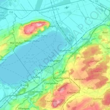
Name: Murten topographic map, elevation, terrain.
Average elevation: 480 m
Minimum elevation: 423 m
Maximum elevation: 652 m
Other topographic maps
Click on a map to view its topography, its elevation and its terrain.
Mont-Vully
Zwitserland > Fribourg/Freiburg > Seebezirk / District du Lac
Mont-Vully, Seebezirk / District du Lac, Fribourg/Freiburg, Zwitserland
Average elevation: 449 m
Môtier (Vully)
Zwitserland > Fribourg/Freiburg > Seebezirk / District du Lac > Mont-Vully > Môtier (Vully)
Môtier (Vully), Mont-Vully, Seebezirk / District du Lac, Fribourg/Freiburg, 1787, Zwitserland
Average elevation: 466 m