
Elbeuf topographic map
Interactive map
Click on the map to display elevation.
About this map
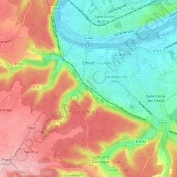
Name: Elbeuf topographic map, elevation, terrain.
Average elevation: 72 m
Minimum elevation: 2 m
Maximum elevation: 154 m
Other topographic maps
Click on a map to view its topography, its elevation and its terrain.
La Bouille
Frankreich > Normandie > Seine-Maritime > La Bouille
La Bouille, Rouen, Seine-Maritime, Normandie, Metropolitanes Frankreich, 76530, Frankreich
Average elevation: 64 m
Rouen
Frankreich > Normandie > Seine-Maritime
Rouen, Seine-Maritime, Normandie, Metropolitanes Frankreich, Frankreich
Average elevation: 72 m