
Pol topographic map
Interactive map
Click on the map to display elevation.
About this map
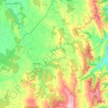
Name: Pol topographic map, elevation, terrain.
Location: Pol, Meira, Lugo, Galicien, Spanien (43.07226 -7.43005 43.21333 -7.23384)
Average elevation: 589 m
Minimum elevation: 311 m
Maximum elevation: 1,027 m
Other topographic maps
Click on a map to view its topography, its elevation and its terrain.
San Xurxo de Piquín
Spanien > Galicien > Meira > Ribeira de Piquín
San Xurxo de Piquín, Ribeira de Piquín, Meira, Lugo, Galicien, Spanien
Average elevation: 537 m