
Avesnes topographic map
Interactive map
Click on the map to display elevation.
About this map
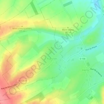
Name: Avesnes topographic map, elevation, terrain.
Average elevation: 147 m
Minimum elevation: 110 m
Maximum elevation: 196 m
Other topographic maps
Click on a map to view its topography, its elevation and its terrain.
Rivière d'Hamès-Bources
France > Hauts-de-France > Pas-de-Calais > Hames-Boucres
Average elevation: 2 m
Le Courtil des Sept Mesure
France > Hauts-de-France > Pas-de-Calais > Echinghen > Le Courtil des Sept Mesure
Average elevation: 63 m