
Hoge topographic map
Interactive map
Click on the map to display elevation.
About this map
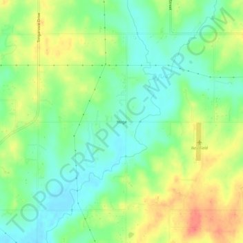
Name: Hoge topographic map, elevation, terrain.
Location: Hoge, Leavenworth County, Kansas, United States (39.15222 -95.01497 39.19222 -94.97497)
Average elevation: 276 m
Minimum elevation: 254 m
Maximum elevation: 306 m
Other topographic maps
Click on a map to view its topography, its elevation and its terrain.
Maywood
United States > Kansas > Leavenworth County > Leavenworth
Maywood, Leavenworth, Leavenworth County, Kansas, 64092, United States
Average elevation: 246 m
Fairmount
United States > Kansas > Leavenworth County
Fairmount, Leavenworth County, Kansas, United States
Average elevation: 290 m
Leavenworth
United States > Kansas > Leavenworth County
Leavenworth, Leavenworth County, Kansas, United States
Average elevation: 268 m
Linwood
United States > Kansas > Leavenworth County
Linwood, Leavenworth County, Kansas, United States
Average elevation: 248 m
Basehor
United States > Kansas > Leavenworth County
Basehor, Leavenworth County, Kansas, 66007, United States
Average elevation: 286 m
Fort Leavenworth
United States > Kansas > Leavenworth County > Leavenworth > Leavenworth
Fort Leavenworth, Leavenworth, Leavenworth County, Kansas, 66027, United States
Average elevation: 252 m
Lansing
United States > Kansas > Leavenworth County
Lansing, Leavenworth County, Kansas, 66043, United States
Average elevation: 266 m
Leavenworth
United States > Kansas > Leavenworth County > Leavenworth
Leavenworth, Leavenworth County, Kansas, 66048, United States
Average elevation: 277 m