
Make a donation
Gear up for your next adventure:
As an Amazon Associate, this site earns from qualifying purchases at no extra cost to you.
Salawu topographic map
Click on the map to display elevation.
Make a donation
Gear up for your next adventure:
As an Amazon Associate, this site earns from qualifying purchases at no extra cost to you.
About this map
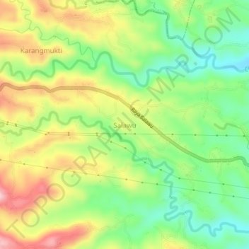
Name: Salawu topographic map, elevation, terrain.
Location: Salawu, Tasikmalaya, West Java, Java, 46471, Indonesia (-7.39157 108.00338 -7.35157 108.04338)
Average elevation: 570 m
Minimum elevation: 474 m
Maximum elevation: 693 m
Make a donation
Gear up for your next adventure:
As an Amazon Associate, this site earns from qualifying purchases at no extra cost to you.
Other topographic maps
Click on a map to view its topography, its elevation and its terrain.
Dusun Gunung Medang, Desa Kawitan, Kec. Salopa, Kab. Tasikmalaya
Indonesia > West Java > Tasikmalaya
Average elevation: 498 m
Make a donation
Gear up for your next adventure:
As an Amazon Associate, this site earns from qualifying purchases at no extra cost to you.
Dusun Cilangkap, Desa Cisempur, Kec. Cibalong, Kab. Tasikmalaya
Indonesia > West Java > Tasikmalaya > Cisempur
Average elevation: 198 m
Make a donation
Gear up for your next adventure:
As an Amazon Associate, this site earns from qualifying purchases at no extra cost to you.