
Konathukunnu topographic map
Interactive map
Click on the map to display elevation.
About this map
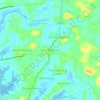
Name: Konathukunnu topographic map, elevation, terrain.
Average elevation: 9 m
Minimum elevation: -3 m
Maximum elevation: 28 m
Other topographic maps
Click on a map to view its topography, its elevation and its terrain.
Velli Kulangara
India > Kerala > Mukundapuram
Velli Kulangara, Mukundapuram, Thrissur District, Kerala, 680125, India
Average elevation: 8 m
Karingachira
India > Kerala > Mukundapuram > Puthenchira
Karingachira, Puthenchira, Mukundapuram, Thrissur District, Kerala, India
Average elevation: 6 m
Irinjalakuda
India > Kerala > Mukundapuram
Irinjalakuda, Mukundapuram, Thrissur, Kerala, 680100, India
Average elevation: 7 m
Thalore
India > Kerala > Mukundapuram > Thalore
Thalore, Mukundapuram, Thrissur district, Kerala, 680313, India
Average elevation: 12 m