
Chantôme topographic map
Interactive map
Click on the map to display elevation.
About this map
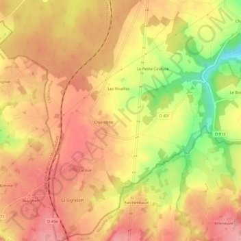
Name: Chantôme topographic map, elevation, terrain.
Average elevation: 286 m
Minimum elevation: 210 m
Maximum elevation: 326 m
Other topographic maps
Click on a map to view its topography, its elevation and its terrain.
Bousset
France > Centre-Val de Loire > Indre > Éguzon-Chantôme > Éguzon
Bousset, Éguzon, Éguzon-Chantôme, Châteauroux, Indre, Centre-Val de Loire, France métropolitaine, 36270, France
Average elevation: 246 m
Les Gonnins
France > Centre-Val de Loire > Indre > Éguzon-Chantôme
Les Gonnins, Chantôme, Éguzon-Chantôme, Châteauroux, Indre, Centre-Val de Loire, France métropolitaine, 36270, France
Average elevation: 284 m
Éguzon-Chantôme
France > Centre-Val de Loire > Indre > Éguzon-Chantôme > Éguzon-Chantôme
Éguzon-Chantôme, Châteauroux, Indre, Centre-Val de Loire, France métropolitaine, 36270, France
Average elevation: 255 m
Chambon
France > Centre-Val de Loire > Indre > Éguzon-Chantôme
Chambon, Éguzon-Chantôme, Châteauroux, Indre, Centre-Val de Loire, France métropolitaine, 36270, France
Average elevation: 243 m
Les Jarriges
France > Centre-Val de Loire > Indre > Éguzon-Chantôme
Les Jarriges, Éguzon-Chantôme, Châteauroux, Indre, Centre-Val de Loire, France métropolitaine, 36270, France
Average elevation: 237 m