
Rotter See topographic map
Interactive map
Click on the map to display elevation.
About this map
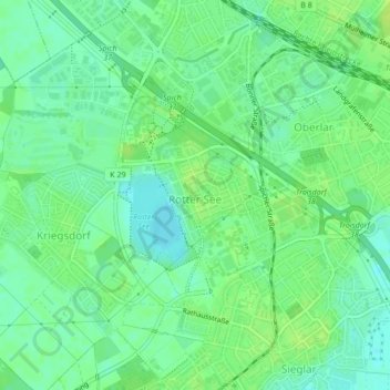
Name: Rotter See topographic map, elevation, terrain.
Average elevation: 57 m
Minimum elevation: 49 m
Maximum elevation: 63 m
Other topographic maps
Click on a map to view its topography, its elevation and its terrain.
Spich
Deutschland > Nordrhein-Westfalen > Rhein-Sieg-Kreis > Troisdorf
Spich, Troisdorf, Rhein-Sieg-Kreis, Nordrhein-Westfalen, 53842, Deutschland
Average elevation: 65 m
Sieglar
Deutschland > Nordrhein-Westfalen > Rhein-Sieg-Kreis > Troisdorf
Sieglar, Troisdorf, Rhein-Sieg-Kreis, Nordrhein-Westfalen, Deutschland
Average elevation: 55 m