
Make a donation
Gear up for your next adventure:
As an Amazon Associate, this site earns from qualifying purchases at no extra cost to you.
Pethericks Corners topographic map
Click on the map to display elevation.
Make a donation
Gear up for your next adventure:
As an Amazon Associate, this site earns from qualifying purchases at no extra cost to you.
About this map
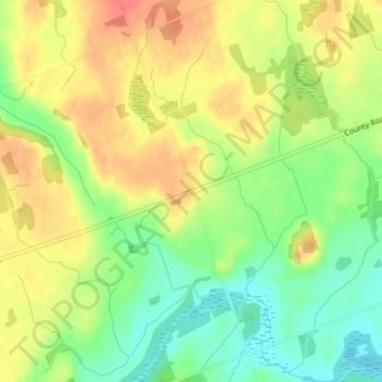
Name: Pethericks Corners topographic map, elevation, terrain.
Average elevation: 181 m
Minimum elevation: 152 m
Maximum elevation: 207 m
Make a donation
Gear up for your next adventure:
As an Amazon Associate, this site earns from qualifying purchases at no extra cost to you.
Other topographic maps
Click on a map to view its topography, its elevation and its terrain.
Trent River
Canada > Ontario > Northumberland County > Trent Hills > Trent River
Average elevation: 197 m
Ferris Provincial Park
Canada > Ontario > Northumberland County > Trent Hills > Campbellford
Average elevation: 151 m
Make a donation
Gear up for your next adventure:
As an Amazon Associate, this site earns from qualifying purchases at no extra cost to you.