
Thank you for supporting this site ❤️
Make a donation
Make a donation
Gear up for your next adventure:
As an Amazon Associate, this site earns from qualifying purchases at no extra cost to you.
Luanda topographic map
Click on the map to display elevation.
Thank you for supporting this site ❤️
Make a donation
Make a donation
Gear up for your next adventure:
As an Amazon Associate, this site earns from qualifying purchases at no extra cost to you.
About this map
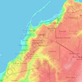
Name: Luanda topographic map, elevation, terrain.
Location: Luanda, Municipality of Luanda, Luanda Province, Angola (-8.92083 13.17323 -8.75923 13.31086)
Average elevation: 44 m
Minimum elevation: -2 m
Maximum elevation: 100 m
Thank you for supporting this site ❤️
Make a donation
Make a donation
Gear up for your next adventure:
As an Amazon Associate, this site earns from qualifying purchases at no extra cost to you.
Other topographic maps
Click on a map to view its topography, its elevation and its terrain.
Samba Urban District
Angola > Luanda Province > Municipality of Luanda > Luanda
Average elevation: 41 m