
Make a donation
Gear up for your next adventure:
As an Amazon Associate, this site earns from qualifying purchases at no extra cost to you.
Borgholm topographic map
Click on the map to display elevation.
Make a donation
Gear up for your next adventure:
As an Amazon Associate, this site earns from qualifying purchases at no extra cost to you.
Borgholm
The name Borgholm is documented to be found from the 1280s. The foreland Borg- is considered to refer to the old ancient castle which is believed to have been located on the site of the castle ruins, but according to another interpretation refers to the eye-catching topography of the site. The significance would then be that berg- is the correct interpretation, and support for this can be found in Gotlandic, where borg can mean beach hill or high sand dune, and that berg-meaning has been well spread throughout the East Nordic area.
Make a donation
Gear up for your next adventure:
As an Amazon Associate, this site earns from qualifying purchases at no extra cost to you.
About this map
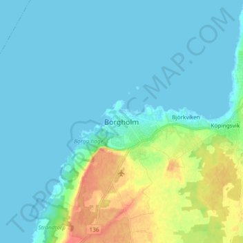
Name: Borgholm topographic map, elevation, terrain.
Location: Borgholm, Borgholms kommun, Kalmar County, 387 31, Sweden (56.83993 16.61614 56.91993 16.69614)
Average elevation: 10 m
Minimum elevation: -1 m
Maximum elevation: 48 m
Make a donation
Gear up for your next adventure:
As an Amazon Associate, this site earns from qualifying purchases at no extra cost to you.
Other topographic maps
Click on a map to view its topography, its elevation and its terrain.
Make a donation
Gear up for your next adventure:
As an Amazon Associate, this site earns from qualifying purchases at no extra cost to you.
Make a donation
Gear up for your next adventure:
As an Amazon Associate, this site earns from qualifying purchases at no extra cost to you.