Geolocate

Ludwigslust topographic map

Interactive map

Click on the map to display elevation.

About this map

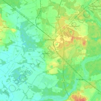
Name: Ludwigslust topographic map, elevation, terrain.

Location: Ludwigslust, Ludwigslust-Parchim, Mecklenburg-Vorpommern, 19288, Germany (53.25871 11.32020 53.37284 11.54345)

Average elevation: 32 m

Minimum elevation: 20 m

Maximum elevation: 61 m

Other topographic maps

Click on a map to view its topography, its elevation and its terrain.

Vielank

Germany > Mecklenburg-Vorpommern > Ludwigslust-Parchim

Vielank, Dömitz-Malliß, Ludwigslust-Parchim, Mecklenburg-Vorpommern, Germany

Average elevation: 20 m

Valluhn

Germany > Mecklenburg-Vorpommern > Ludwigslust-Parchim > Lüttow-Valluhn

Valluhn, Lüttow-Valluhn, Zarrentin, Ludwigslust-Parchim, Mecklenburg-Vorpommern, Germany

Average elevation: 32 m

Below

Germany > Mecklenburg-Vorpommern > Ludwigslust-Parchim > Below

Below, Techentin, Goldberg-Mildenitz, Ludwigslust-Parchim, Mecklenburg-Vorpommern, 19399, Germany

Average elevation: 66 m

Brüel

Germany > Mecklenburg-Vorpommern > Ludwigslust-Parchim

Brüel, Sternberger Seenlandschaft, Ludwigslust-Parchim, Mecklenburg-Vorpommern, 19412, Germany

Average elevation: 32 m

Parchim

Germany > Mecklenburg-Vorpommern > Ludwigslust-Parchim

Parchim, Ludwigslust-Parchim, Mecklenburg-Vorpommern, Germany

Average elevation: 61 m

Warsow

Germany > Mecklenburg-Vorpommern > Ludwigslust-Parchim

Warsow, Stralendorf, Ludwigslust-Parchim, Mecklenburg-Vorpommern, Germany

Average elevation: 45 m